


Ladakh was a British frontier post on the land route to China through the Karakoram Pass. Ladakh was under Wazir Wazarat, who also responsible for Baltistan and had three tehsils, namely Skardu, Kargil, and Ladakh. In winters Wazir Wazarat used to reside in Skardu, Baltistan. Historically, Skardu held a strategic position towards Ladakh (IOK) on one side and the other beyond Karakoram Pass in Yakand valley in China. The Ladakhi belong to the Mongolian race, mostly of short height and the people of Baltistan are also of Tibetan origin and differ from the Ladkhi, being taller with different social habits and being Muslims.
At the same time, the people of Gilgit-Baltistan also have close religious, ethnic links with the people of Kargil. The main languages spoken are Shina and Balti, the languages of Gilgit-Baltistan. During the liberation war of 1948, the liberation forces occupied Dras and Kargil and were also knocking the doors of Leh. The areas were re-occupied by the Indian army when liberation forces retreated to Olding for regrouping when ceasefire was announced. Today, the Pakistan army has strategic superiority where it threatens the line of communication to Siachen through Kargil.
The Siachen glacier is situated in Baltistan west of Daulat Beg Oldi is of immense significance. India started occupying key peaks in April 1984 in a major airborne operation “Meghdoot”. From the Indian occupation sites, the terrain slopes down to positions held by Pakistan army which leads to major towns in Baltistan. The longest river of Pakistan Indus originates from Manasarovar lake in Tibet, flows through Tibet, Ladakh enters Skardu, flows to Gilgit and to Terbella. Shyok river originates from Rimo glacier and joins Naubra river at Disket flows through Chalunka, Turtuk, Tyakshi and Thang (Pakistani villages occupied in 1971 war) and enters Baltistan at Fraono village. The Shyok river joins Indus river at Keris short of Skardu.
On March 3, 1963, the China-Pakistan border agreement was signed amicably; contrary to rumours/reports by Indian media that an area from 2000 to 13000 square kilometres was ceded to China is totally unfounded and baseless. The fact is that Pakistan has not ceded even one square inch of land to China, rather it has gained 750 square miles of territory which was under Chinese control in the area of Shimshal and K2. Article 6 of the agreement envisages its revision after conclusion of the Jammu and Kashmir settlement.
Pakistan did not have any border dispute with China rather we have serious issues with India on the Line of Control (LoC) and the Working Boundary. Similarly, China did not recognise the Johnson Line in Ladakh, but agrees to the Macartney-Macdonald Line, which puts Askai Chin in Chinese territory. China also did not recognise the length of the border with India from 4056 kilometres to 3488 kilometres as claimed by the Indian ministry of defence and the Ambassador to China respectively. According to Chinese officials, the length of border is 2000 kilometres, 1600 kilometres less than what is believed by India’s ministry of external affairs. This is the total length of boundary which separates Kashmir from Xinjiang and Tibet which is not recognised by China.
On August 5, 2019 India revoked the special status of Indian Occupied Kashmir by abrogating Article 370 and 35 A of the Indian constitution. India issued a new political map where Azad Kashmir was shown as part of a newly-created union territory of Jammu and Kashmir and Gilgit-Baltistan and Askai Chin as part of the union territory of Ladakh. With these developments, India has destroyed all the agreements, treaties and boundaries which are now null and void like the Simla agreement, the Line of Control and the Line of Actual Control.
On May 5, 2020 in a brilliant military manoeuvre, Chinese landed its troops in the Galwan Valley, Pangong Lake area and Nathu La. A bloody military confrontation took place on June 15, 2020 where 23 Indian soldiers were stoned to death without firing a bullet by PLA in the area of patrol point 14 in Galwan River Valley.
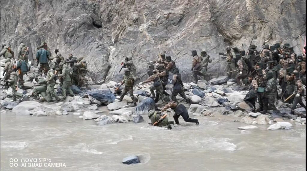
According to the PLA, this was the result of a provocative attack launched by the Indian army in the valley. According to PLA, Indian army crossed the LAC and launched a physical attack on them. Galwan River is named after Ghulam Rasul Galwan, the son of a Yarkandi while his mother was Kashmiri from the Galwan tribe who found the source of the Galwan River. The river originates from Askai Chin and joins Shyok river on the road to Daulat Beg Oldi. The significance and importance of Galwan Valley is that control of the ridges (now under Chinese occupation) dominate the newly constructed 255-kilometre road in eastern Ladakh, Sub-Sector North (SSN). At the same time, if India gets hold of Galwan Valley, this will give her access to the Askai Chin plateau through which the Xinjiang-Tibet Highway passes. During the recent talks at Corp Commander level a buffer was agreed and created between the LAC and the junction of Shyok and Galwan river where it was agreed that both sides will go back one kilometre each. This was violated by the Indian army by sending a raiding party under Colonel Santosh to capture Chinese post to improve ground posture in the Galwan valley.
The Chinese were alert and Indians never expected the response from Chinese who responded with iron rods, batons wrapped in barbed wire and reportedly some soldiers of the 16th Bihar regiment jumped into Galwan River in a desperate attempt to escape. At least 23 soldiers, including the commanding officer were killed and the toll will likely go up. During the 1962 war, 36 Indian soldiers of 5 Jat regiment were killed by PLA in the Galwan area, many were taken prisoner and the post was captured.
These are the worst losses since 1967 when 88 Indian soldiers were killed in Nathu La. According to PLA spokesperson the sovereignty over the Galwan valley has always belonged to China. China claim line is to the west of Galwan River along the mountain ridges joining Shyok river valley. The capture of Galwan river valley and ridges provides the PLA dominating position over looking Darbuk-Shyok-Daulat Beg Oldi road which connects Leh with Karakoram Pass. The traffic on the road has been cut at the mercy of PLA. Let me also clear the misconception often quoted by some pseudo intellectuals that Karakoram Highway is close by. It is Karakoram Pass which connects Ladakh with China, 8 miles north of Daulat Beg Oldi. Karakoram Highway is almost 300 kilometres west of Daulat Beg Oldi. Apparently, a Chinese brigade force is now in the valley with two battalions holding the shoulders (ridges) and a battalion group in reserves. Indians have made a serious miscalculation in their over-confidence and underestimated Chinese capabilities and landed themselves in trouble. All the political and military leadership are making desperate attempts to defuse the situation and are begging for talks. The ground reality is that nothing will change as Chinese will never vacate the territory they occupied. A future link up between Pakistan and China in the area cannot be ruled out.


