

The Radcliffe Commission on the direction of Mountbatten gave the Muslim majority tehsil Gurdaspur, which was contiguous to Pakistan to India. According to Alastair Lamb in his book “Incomplete Partition”, the key to accession of Jammu and Kashmir lay through the Gurdaspur district by way of Indian rail head at Pathankot. The only link available to British India was from Rawalpindi – Murree – Muzaffarabad – Baramula – Srinagar Road that followed the Jhelum River and the Sialkot-Srinagar Road that crossed the 9,000 feet high Banihal Pass in Pir Panjal Range. However, during the war of 1948, India took the matter to the UN and a ceasefire was agreed.
The ceasefire line was renamed Line of Control (LOC) in the Simla Agreement of 1972. That the direction of Mountbatten gave the Muslim majority tehsil Gurdaspur, whiche borders between the two countries are known as the world’s most dangerous borders which include the Line of Control (LOC), Working Boundary (WB) and International Border (IB). Similarly, China has serious border issues with India over Aksai Chin (Ladakh), IIOJK and elsewhere. On June 15, 2020 a bloody clash took place in Galwan valley killing 22 soldiers of 16 Bihar Regiment of Indian army. The Chinese PLA has captured another 1,000 square kilometers area in Eastern Ladakh close to their claim line. Several rounds of corps commanders level talks have failed and as China has made it clear that it will not go back by even an inch. With the excellent infrastructure developed by China like the G219 Highway which connects Tibet with Xingjian region and passes through Aksai Chin to hold on to all areas logistically.
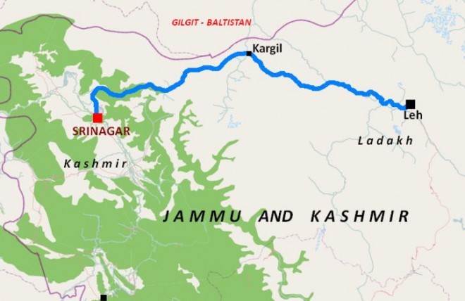
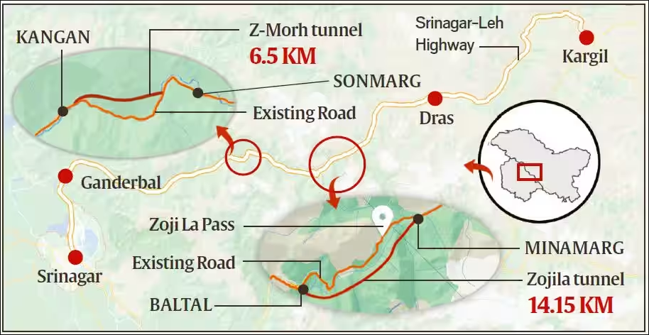
India has been in a dilemma over supporting its troops deployed ahead of the Zojila Pass mainly in the Ladakh region of IIOJK. Therefore, India has started building chains of tunnels and railway tracks to connect Ladakh (IIOJK) from a strategic point of view. India is constructing 20 tunnels in Kashmir and 11 in Ladakh to ensure all weather access to the region. A tunnel which is the largest in Asia (14.5 km) is under construction which will bypass the Zojila Pass. The tunnel will connect Sonamarg with Minamarg (Drass) which will reduce travelling time between the two locations. The construction of tunnel was started in 2018 and will be completed by 2024, however it will be available to Indian army from 2023 onwards. The tunnel will provide round the year connectivity between Srinagar and Kargil (Ladakh) which remain closed for seven months in winters.
Another tunnel is the Banihal-Qazigund road tunnel which is 8.45 kilometers long and reduces road distance between Banihal in Jammu and Qazigund in Kashmir valley by 16 kilometers. The Banihal to Baramula train is currently running which is 135 kilometers long. Now the Jammu-Udhampur-Katra-Banihal-Qazigund to Baramula railway track (356 km) is in progress. A 12.6 km long tunnel is being built on the 111 km long railway track that connects Katra to Banihal. There will be 37 bridges along Banihal route including 35 tunnels is Srinagar and 26 major and 11 small bridges. The longest railway bridge is almost completed close to village Kavari in district Reasi which is the tallest in the world.
New highways are also being constructed and existing ones are being expanded as two corridors are under construction, namely Jammu-Srinagar corridor and Srinagar-Leh corridor. These developments (tunnels & railway lines) will facilitate the movement of logistics, shifting of troops and arms/ammunition towards Line of Actual Control (LAC), Line of Control (LOC) and Siachen Glacier. On the completion of the Zojila Pass tunnel, the 32 kilometers distance from Sonamarg to Minamarg (Drass) will be covered in 15 minutes instead of 4 hours. The tunnel will help the Leh based 14 corps with rush of reinforcement and logistics with greater flexibility because previously logistics were shipped to Leh by air. Tunnels and railway links will provide logistics and operational flexibility for Indian armed forces deployed in Ladakh region against Pakistan and China.
On completion of these projects, the BJP-RSS led government will take full credit and will use it for their election campaign in 2024. The environmental experts in Pakistan have expressed their concern of environmental hazards because India is dumping millions of tonnes of rocks, loose soil and silt in the Jhelum River. This may result in the reduction of the storage capacity of Mangla Dam and this is something which must be addressed urgently.


