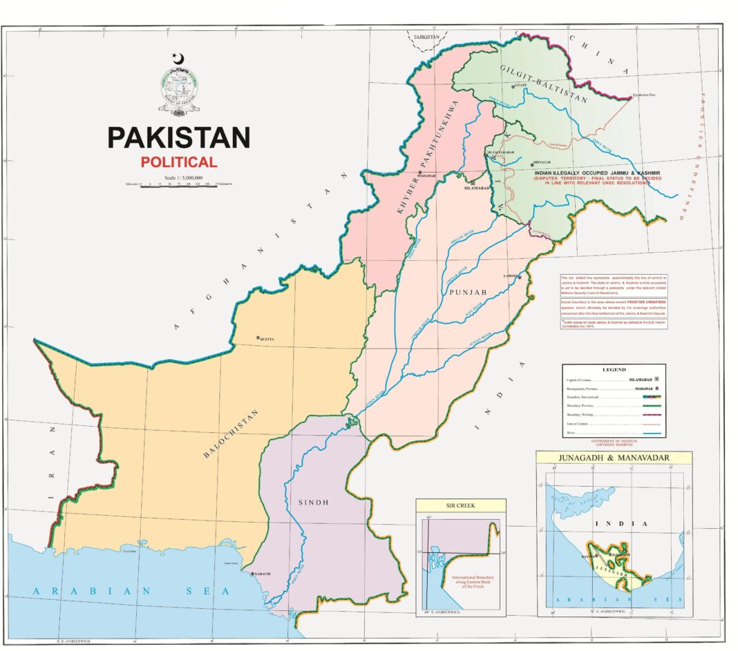
On August 5, 2019, India revoked the special status of Indian Illegally Occupied Jammu and Kashmir (IIOJK) by abrogating Article 370 and 35A of the Indian constitution. This was followed by the issuing of a new political map where Azad Kashmir was shown as part of IIOJK while Gilgit-Baltistan was incorporated in the newly created union territory of Ladakh. Indian National Security Advisor, Ajit Doval, went on the record to say, “we also have a 106 kilometers long non-contiguous border with Afghanistan (Wakhan Corridor).” The Gilgit-Baltistan assembly condemned the new Indian map and passed a unanimous resolution against it. On August 5, 2020, on the completion of the one-year military siege of Occupied Kashmir, Pakistan has unveiled a new political map where the entire region of IIOJK has been shown as an integral part of Pakistan. In the case of the disputed territory of Indian Illegally Occupied Kashmir (IIOK), Pakistan has reaffirmed the United Nations’ (UN) plebiscite and resolutions.
In the new map, it has been made clear that Siachen was ours yesterday and is ours today as well. Siachen was not clearly demarcated in the 1949 Karachi Agreement that defined the Cease Fire Line (CFL) and instead identified the glacier, beyond NJ 9842, in relation to the land as ‘thence north to the glacier.’ Pakistan has controlled and administered the region since 1947. Several mountaineering and trekking expeditions to the Siachen glacier were authorised by the country. Atlases reflecting the Pakistani Line of Control (LOC) were produced in the US and UK by the National Geographic and Encyclopaedia Britannica as well.
In 1984, through a major airborne operation, India occupied some key peaks in the area while there were no Pakistani troops. In the new map, Ladakh has been shown as a part of Pakistan. Historically people of Gilgit-Baltistan have religious, ethnic and linguistic links with the people of Drass and Kargil. According to R. C Arora, the Dards (people) of Gilgit and Astor ruled the area –evident from the sculptures and drawings found at Khalatse and Hanupatar. Today, 46 percent of its population is Muslim, 40 percent Buddhist and 12 percent Hindu. Drass and Kargil were captured by the liberation forces of Gilgit during the war of 1947/48.
Ladakh had three tehsils, Skardu, Kargil and Ladakh, and was administered by a wazir-e-wazarat who used to reside in Skardu during the winters. Similarly, Indian claims on Sir Creek have been refuted since the new map makes it clear that Pakistan’s border is on the east instead of the west, as claimed by India. Sir Creek is a 96-kilometre strip in the Rann of Kutch, a salt marsh land, that opens to the Arabian sea and divides the Kutch region between Sindh and Gujrat. Pakistan claims the entire creek as its own in accordance with the 9th paragraph of the 1914 resolution, signed between the government of Sindh and Rao Maharaj of Kutch, which demarcated the boundaries between Sindh and Bombay. The creek was made a part of Sindh, setting the boundary on the eastern flank of the creek.
Pakistan claims that Junagadh and Manavadar too have been underscored. Junagadh was a princely state in British India which was given the choice of either merging with India or Pakistan at the time of independence. On August 11, 1947, Nawab Muhammad Mahabat Khanji announced Junagadh’s merger with Pakistan. The ruler of the state was a Muslim whereas the majority population was Hindu—a situation similar to that of IIOK. The Nawab’s decision was not well received by Nehru and Patel who argued that the state has no contiguous border with Pakistan. The Nawab justified his decision by highlighting the state’s sea links with Pakistan. In the meantime, Quadi-e-Azam accepted the accession of Junagadh. In February, 1948, a staged referendum announced that 95 percent of the people voted for India, allowing the Indian army to take action while the Nawab escaped to Karachi. Another interesting point in history is that the prime minister of Junagadh at that time was Sir Shahnawaz Bhutto. The famous Somnath temple is located in Junagadh.
In the new map, the erstwhile FATA has been shown as part of the KP province merged after the 25th constitutional amendment in May 2018. All of Gilgit-Baltistan and Kashmir had been shown in the same colour to show it as one territory. An administrative boundary separating Azad Jammu and Kashmir, as well as Gilgit-Baltistan, has been inserted in the map. There is a clear international border and the border on the eastern side had been extended upto the undefined frontier to demarcate the Indian territory of Himachal Pradesh from the disputed part.
The new map states that there will be a UN sponsored referendum for Kashmir in the future. India has territorial disputes with its other neighbours too. In the new Indian map, the Chinese territory of Aksai Chin has also been shown as part of the union territory of Ladakh. The Nepalese government also rejected the Indian map since its territory, situated in the far west, has also been included as Indian territory. In June 2020, Nepal issued a new map and areas claimed by India, including Kala Pani, Lipulkeh and Limpiyadhura, were included inside Nepal.
The entire Pakistani and Kashmiri leadership has endorsed the new map. It is a bold and visionary decision in the right direction. The government has decided to present the new map to the Organisation of Islamic Cooperation (OIC), UN and other international organisations. The government of Pakistan has also decided to send the country’s official map to all search engines including Google and Yahoo. Prime Minister Imran Khan said, “The new map reflected the sentiments of the Pakistani nation, the principal stance of Kashmiris for their just right of self-determination and the clear negation of illegal annexation by the Indian government”. The new map will be an inspiration for Kashmiri freedom fighters and will be a reminder to the UN to implement its resolution which calls for the right of self-determination through a plebiscite.


